


Share on


1 Set
$3,0982 Set
$2,998Product information
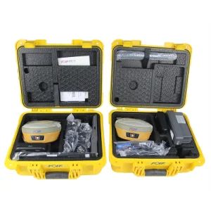
High-quality Surveying Instruments Rtk Foif N90 GPS Rtk for Land Survey Gnss GPS Receiver Rtk supplied by SHANGRAO HAODI IMP&EXP TRADING CO., LTD.. Bulk wholesale pricing ranges from $2,998 to $3,098 per Set with a minimum order of 1 Set. Inquiry for latest prices.
1
1
1000PCS/Month
1mm
3 Years
3 Years
30.000kg
70.00cm * 55.00cm * 45.00cm
1
1
1000PCS/Month
1mm
3 Years
3 Years
30.000kg
70.00cm * 55.00cm * 45.00cm
8526919090
China
Claim a refund if your order doesn't ship, is missing, or arrives with product issues.
Code Related Type
Contact the supplier about freight and estimated delivery time.
FOB, EXW, CIF, DDP
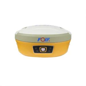
FOIF
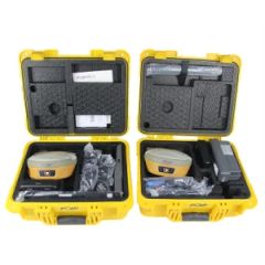
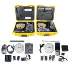
Hard Plastic Case
LC, T/T, PayPal, Western Union
Mstar
Multichannel
N90
SHANGHAI, NINGBO, SHENZHEN
Support payments in USD
China
Not specified
Not specified
2008-07-01
Not specified
Not specified
LC, T/T, PayPal, Western Union
FOB, EXW, CIF, DDP
SHANGHAI, NINGBO, SHENZHEN
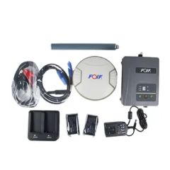
battery


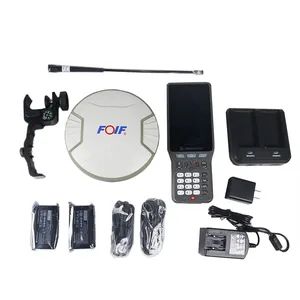
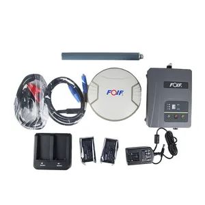
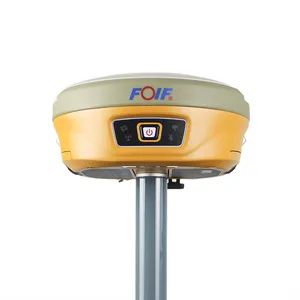
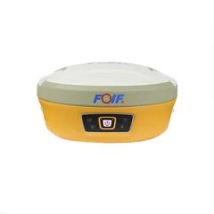
N90 Intelligent GNSS Receiver
| Items | Specification | |
| GNSS Engine | GNSS board | H board |
| Channel | 1408 | |
| Satellites | GPS: L1 C/A, L1C, L2C, L2P, L5 | |
| GLONASS: L1 C/A, L2 C/A, L2P, L3, L5 | ||
| BeiDou: B1, B2, B3 | ||
| Galileo: E1, E5 AltBOC, E5a, E5b, E6 | ||
| NavlC (IRNSS): L5 | ||
| SBAS: L1, L5 | ||
| QZSS: L1 C/A, L1C, L2C, L5, L6 | ||
| L-Band: Up to 5 channels | ||
| Real-Time Accuracy(rms) | SBAS | Horizon: 60cm(1.97ft); Vertical: 120cm(3.94ft) |
| Real-Time DGPS position | Horizon: 40cm(1.31ft); Vertical: 80cm(2.62ft) | |
| Real-Time Kinematic Position | Horizontal: 1cm(0.03ft)+1.0ppm; Vertical: 2.5cm(0.08ft)+1.0ppm | |
| Real-Time Performance | Instant-RTK Intialization | Typically |
| Stop and Go solution | 99.9% reliability | |
| RTK Intialization range | >40km | |
| Post Processing Accuracy(rms) | Static, Rapid Static | Horizontal: 2.5mm(0.008ft) +1.0ppm; |
| Vertical: 5mm(0.016ft)+1.0ppm | ||
| Post-processing Kinematic | Horizontal: 10mm(0.033ft)+1.0ppm; Vertical: 20mm(0.066ft)+1.0ppm | |
| Solutions | Surpad software | Main function include: A90 GNSS Support: configuration, monitoring and control |
| Field Software Suite | Volume computation, Background raster image | |
| Network connectivity, Coordinate System Support: predefined grid systems, predefined datums | ||
| projections, Geoids, local grid | ||
| Map view with colored lines Geodetic Geometry: intersection, azimuth/distance, offsetting, poly-line, curve, area | ||
| Road Construction (3D): Survey Utilities: calculator, RW5 file | ||
| Viewing: Data import/Export: DXF, SHP, RW5 | ||
| Data logging | Recording Interval | 0.1-999 seconds |
| Physical | Flat design | |
| Size | 156mm*76mm | |
| Bottom cover | Aluminum magnesium alloy | |
| Memory | Internal memory | 8GB standard; supports extending to 32GB |
| I/O Interface | TNC port | connecting built-in radio antenna |
| 5-pin lemo port | connecting external power supply and external radio | |
| 7-pin lemo port | (USB+serial port): connecting PC and handheld | |
| Operating system | Linux | Based on Linux; Supports Web UI |
| Voice | Multi-language supported | |
| Tilt survey sensor | Automatic correct system by 30 degree | |
| Data format | Data format | RTCM 2.3 |
| RTCM 3.0.RTCM 3.X | ||
| CMR, CMR+ | ||
| NovAtelX/5CMRx | ||
| Operation | Operation | RTK rover/base, post-processing |
| RTK Network rover | VRS, FKP, MAC | |
| Point-to-point GPRS through Real-time Data | ||
| Server Software (internal GPRS or external cell phone) | ||
| LandXML (FOIF Field Genius support) | Total Station support ( FOIF Field Genius) | |
| Import and stake directly from a DXF File (FOIF Field Genius) | ||
| Office Software | Main functions include: Network post-processing | |
| Integrated transformation and grid system computations | ||
| Pre-defined datums along with use-defined capabilities | ||
| Survey mission planning | ||
| Automatic vector processing | ||
| Least-squares network adjustment | ||
| Data analysis and quality control tools | ||
| Coordinate transformations | ||
| Reporting | ||
| Exporting | ||
| Geoid | ||
| Environmental | Operating temperature | -30ºC to +65ºC(-22°F to 149°F) |
| Storage temperature | -40ºC to +80ºC(-40°F to 176°F) | |
| Humidity | 100% condensing | |
| Waterproof | IP67 (IEC60529) | |
| Shock | 2m (6.56ft) pole drop | |
| 1.2m (3.94ft) free drop | ||
| Power | 7.2v.2 removable batteries (total up to 6800mAh, supports single battery working) | |
| Optional System Components | Communication Module | Internal radio: UHF Link (410-470MHz) |
| 1W | ||
| External radio | R*&*both (5w/35w selectable) | |
| 4G LTE module (EC25 series) | Fits various networks | |
| Bluetooth | 2.1+EDR Class 2 | |
| WiFi | IEEE 802.11 b/g/n | |
| Antenna | Built-in antenna, integrating GNSS, BT/WLAN and network antenna | |
| Controller | F58 | |
Carlson SurvCE/FieldGenius/Surpad
Surpad Software Professional,intuitive and efficient
This RTK data controller Field Software is designed & developped by the most professional software R&D engineers team, which brings you a professional, intuitive and efficient measurement of the new experience. TheSurpad software integrates construction survey, power survey, GIS data collecting in one unit. This software is compatible both with Windows Mobile and Android platform, it also supports the smart phone to be used as data controller.
1. Power Survey
Line selection, cross measurement, 4-D Data Format output.
2. Road survey
Road design, Middle Side Stake Layout, Cross section survey.
3. Base Map Loading
Support vector data loading such as DXF, SHP and GCP.
4. GIS collection
Support Attribute Data Collecting by Self-Defined data dictionary and export GIS exchange format.
5. Post Processing Software GGO
Support to convert the data format into RINEX, which is compatible with AutoCAD and other Drawing & Mapping Software.


Supplier Review
Summary by Vivian
TRUST STARS
3.9/5
0 Reviews
Company Verification
0/4
Profile Completeness
56%
Avg. Product Score
0/5
Responsiveness
0%
Certification
battery
You can contact verified China supplier SHANGRAO HAODI IMP&EXP TRADING CO., LTD. through platforms like Freshdi.com to purchase Surveying Instruments Rtk Foif N90 GPS Rtk for Land Survey Gnss GPS Receiver Rtk. For direct inquiries, please contact Mrs. Annie, the company’s representative. The supplier has a 3.9-star rating on Freshdi and has verified. You’ll receive product details, pricing, and shipping terms directly from supplier.
For Surveying Instruments Rtk Foif N90 GPS Rtk for Land Survey Gnss GPS Receiver Rtk, SHANGRAO HAODI IMP&EXP TRADING CO., LTD. accepts LC, T/T, PayPal, Western Union as the preferred payment method, the trade term is FOB, EXW, CIF, DDP, and shipments are typically arranged from port SHANGHAI, NINGBO, SHENZHEN, ensuring secure and timely international delivery.
The supplier SHANGRAO HAODI IMP&EXP TRADING CO., LTD. offers Surveying Instruments Rtk Foif N90 GPS Rtk for Land Survey Gnss GPS Receiver Rtk at negotiation.
Surveying Instruments Rtk Foif N90 GPS Rtk for Land Survey Gnss GPS Receiver Rtk is sourced from China and meets international export standards. Key specifications include: Vertical Lines: 1, Model NO.: N90, Payment Methods: Support payments in USD, After-Sales Service: 3 Years, Chip: Mstar, Package Size: 70.00cm * 55.00cm * 45.00cm, Trade Term: FOB, EXW, CIF, DDP, Payment Term: LC, T/T, PayPal, Western Union
You are viewing details for Surveying Instruments Rtk Foif N90 GPS Rtk for Land Survey Gnss GPS Receiver Rtk. The information provided here is either posted directly by the supplier, who is responsible for its accuracy, or collected by Freshdi AI from publicly available sources. Freshdi strives to make product information as useful and reliable as possible, but we do not guarantee complete accuracy. If you notice any incorrect or misleading details, please use the Report Product option so our team can review and address it quickly.
$3,098
/ Set
Min. order: 1 Set
Mrs. Annie
Year Established: 2008-07-01
Visit Store